The Bruce Trail app for iPhone and iPad
The Bruce Trail App
Plan, track, and log your hikes on Canada’s oldest and longest marked footpath with this easy-to-use, official Bruce Trail App. Carry the most up-to-date Bruce Trail information with you on your day-hikes or long-distance adventures on the Niagara Escarpment.
The Bruce Trail App features the 42 official topographic maps found in the printed Bruce Trail Reference, Map and Trail Guide – with continuously updated trail information and helpful navigational tools. It can be used with or without cell coverage on the trail.
Proceeds from the sale of this App go towards The Bruce Trail Conservancy.
Features:
=> The Entire Bruce Trail:
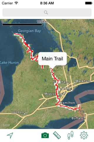
View the full 890 km main Bruce Trail and over 400 km of associated side trails, including any recent trail changes and closed trail sections.
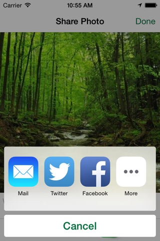
=> Photo Sharing
Take photos and see them plotted on the trail. Share photos with Facebook, Twitter, Tumblr, iMessage, email, and more.
=> Parking Lots and Camping Sites:
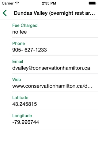
Clearly see locations of trail access points, parking locations, and official camping sites with expanded details.
=> Background Map Options:
Switch between the Bruce Trail topo maps and Apple(TM) Maps satellite photo views; Turn street maps on and off.
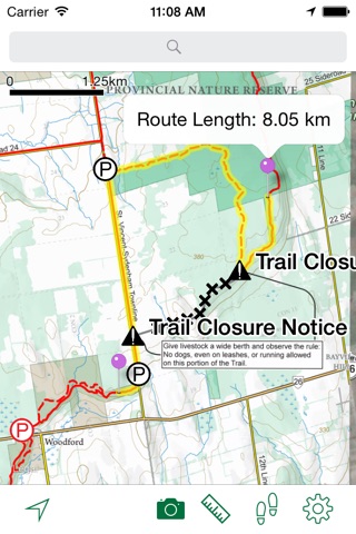
=> Measure the Trail:
Tap along the trail to plan your route and measure the distance you will be hiking. See a dynamic scale bar on the map.
=> Record Tracks:
Record your days hike as a track file and see how far you have traveled. Leave the GPS on as a background task to record your track while you use other Apps or lock the screen. WARNING: Continued use of GPS running in the background can dramatically decrease battery life.
=> Map Pans as You Move:
Track your location with a map that moves as you move. Set the map to keep north up or to rotate with your direction of travel.
=> Download All Maps:
When you have cellular or Wi-Fi access, download all the Bruce Trail topo maps with one tap. You can be certain all the data you need is on your iOS device when you head out on the trail.
=> Find Place Names, Restaurants, Stores, Gas stations and Other Services:
With the built-in Apple(TM) Maps search, quickly locate the services you need within easy access of the trail.
=> Other information:
Find useful information about the Bruce Trail, Blazes, the Bruce Trail Users’ Code, and the topo map legend in an easy reference menu.
___________________________________
About the Bruce Trail:
The Bruce Trail, Canadas oldest and longest marked footpath, provides the only continuous public access to the magnificent Niagara Escarpment, a UNESCO World Biosphere Reserve.
Running along the Escarpment from Niagara to Tobermory, it spans more than 890 km of main trail and over 400 km of associated side trails.
The Bruce Trail Conservancy (BTC) is a charitable organization committed to establishing a conservation corridor containing a public footpath along the Niagara Escarpment, in order to protect its natural ecosystems and to promote environmentally responsible public access to this UNESCO World Biosphere Reserve.
The BTC is one of Ontarios largest land trusts, preserving over 8,000 acres of irreplaceable Niagara Escarpment landscape.
For more information visit brucetrail.org
Pros and cons of The Bruce Trail app for iPhone and iPad
The Bruce Trail app good for
Pretty smooth app for tracking your progress on the go and providing information. I wish the app had all of the information contained in The Bruce Trail guides. E.g. Descriptions of areas. As well, the maps dont have all the information as provided in the guidebooks. (Would love to see the addition of lookouts as on the paper topo maps.). I was under the impression that I might see others photos from the trail but this is not the case. Would also like the ability to continue a track. I of you close the app, you have to start a new track for your r progress. All in all, following your progress and determining location worked great!
Admittedly I havent explored all the features of this app yet, but it was worth buying just to have the full trail maps at my fingertips without having to fuss around with PDFs on my phone or carrying the paper versions. Love it! And the app has the advantage that the maps can be updated and kept current. Thanks for this, I will be using it a lot.
Been waiting for a Bruce Trail-specific app like this for a while. Totally worth it and it goes to a good cause. Ive used it for planning routes ahead of time, but the BEST feature is always knowing exactly where you are on the trail, particularly if you take a wrong turn or lose sight of the blazes. You can take photos and they appear on the map where they were taken. Would give it 5 stars if it showed route elevation and could somehow link/download data to my online BT member profile.
I am delighted to have this app available; worth every penny. One small thing though. Could we have the option to turn off the satellite view and just use the topo? The constant refreshing when moving across the map is irritating and inefficient.
We rarely get out our paper maps now for hiking The Bruce Trail. Good distance measuring tool too.
I can tap anywhere on a trail using the distance tool, then tap anywhere else on the trail and the app gives me the distance between locations on the trail. Works great. I asked The Bruce Trail about mile markers. They say they are in the printed guidebook but they change each time the main trail is rerouted as they start from mile "0" in Niagara. So the mile markers are "virtual". Apparently the App can be better than the guidebook because they are considering adding a feature to give you the mile (actually kilometer...) measure from the start of the trail automatically when you tap anywhere on the main trail. This will be good. I hope it comes out soon!
Some bad moments
This app has potential. Convenient to use on a mobile, no need to carry paper maps. What it needs is trail names and trail distance for planing a hike. This info could be in the form of a button as in the parking info.
Does not work well, in fact never works, might be due to IOS 8. Crashes constantly, can even hang the complete iPhone.
When I first installed it, when it first got released, it worked for about 10 hikes. Since then, isnt worth paying for, it just resets, reboots, 1.3 seems especially bad.
App stays on for about two seconds max. Then shuts off. Turning phone on and off doesnt matter - still doesnt work. Would not recommend.
A little better than Google maps. However, the main feature - the one that is supposed to measure distances between point a and point b -- doesnt work.
Warning to all looking at this app. I paid 9.99 and the app crashes constantly. Complete waste of money. You might as well write a check to The Bruce Trail, saying "heres my 10.00 donation" as you wont be able to use this app.
The track function is unusable.
App crashes regularly.
The resolution on the topographical maps is terrible. I spent $19.95 on it and now wish I had just purchased the email package of topos (although I can only hope the resolution on that download would be better, but I dont know that for sure).